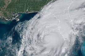
Dramatic satellite imagery released by the National Oceanic and Atmospheric Administration (NOAA) has revealed the sheer power of Hurricane Milton as it made landfall in Florida, striking the state with catastrophic force. The hurricane, which hit Florida’s west coast near Siesta Key on Wednesday, was classified as a Category 3 storm, with maximum winds reaching up to 120 miles per hour.
The satellite footage, made public on Thursday, showcases Milton’s spiraling mass over the southeastern United States, with striking visuals of its eye surrounded by dense cloud bands stretching hundreds of miles. Meteorologists highlighted the frequent lightning activity detected by the satellite’s Geostationary Lightning Mapper (GLM), illuminating the storm’s center and serving as a reminder of the extreme weather conditions at play.
“This imagery from NOAA’s GOES-East provides visible cloud imagery every 30 seconds of Hurricane Milton as it pushes closer to Florida,” the agency stated. “Notice the frequent lightning being detected by the satellite’s GLM instrument as well.”
One of the most captivating aspects of the satellite imagery is the impressive display of lightning flashes observed in southern Florida, where several tornadoes reportedly formed during the storm’s passage. This extraordinary light show within the storm system underscores the severe weather experienced on the ground.
As Hurricane Milton moved across central Florida on Thursday, it left a trail of destruction in its wake. The hurricane caused extensive damage, uprooting trees, destroying homes, and leaving nearly 2 million residents without power across the state. Emergency management officials are working tirelessly to assess the damage and coordinate relief efforts in affected areas.
Meteorologists and emergency management officials continue to monitor satellite data to track Milton’s trajectory and intensity, information crucial for issuing timely alerts and coordinating emergency responses.
The situation remains dynamic as recovery efforts are underway. Residents are urged to stay informed through local news and official channels as recovery teams work to restore power and assist those affected by this devastating storm.
Sources By Agencies


